Spain Map

Spain Map — Regions, Islands & Geography Explained
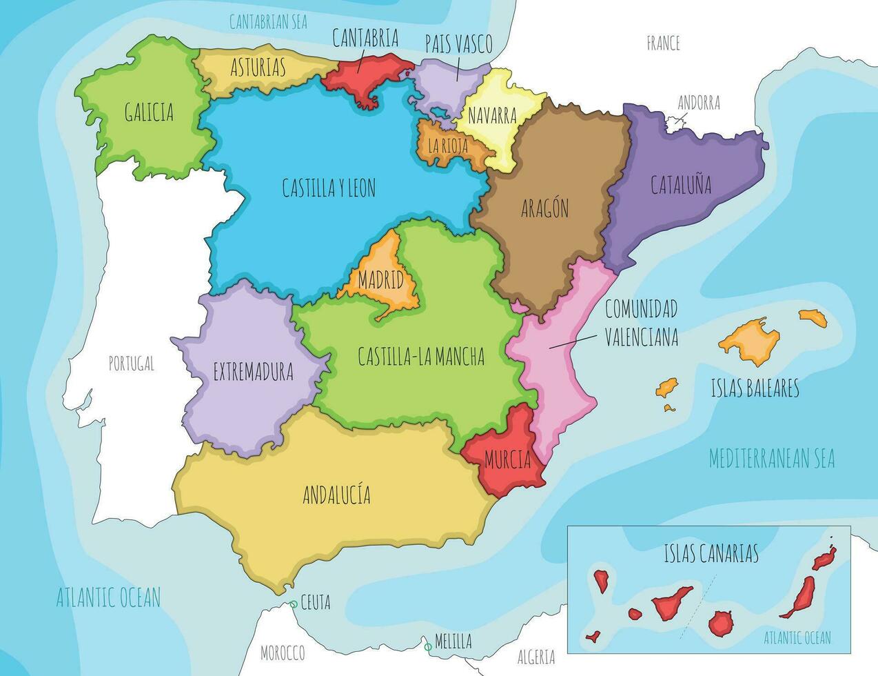
This illustrated map helps travelers quickly understand Spain’s autonomous communities, major regions and island territories before diving into detailed route or destination planning.
Spain looks compact on a map, but once you start planning a trip you realise how big and varied it really is. From the green Atlantic coasts of Galicia and the Basque Country to the dry plateaus around Madrid and the volcanic landscapes of the Canary Islands, each area offers a different travel experience. Understanding Spain’s geography is one of the easiest ways to choose where to go, how to move around and how much time you actually need.
This Spain map page gives you a practical, traveller-focused overview. Instead of a technical geography lesson, you will find plain-language explanations of how the country is organised, which regions sit where, how far the main cities are from each other and what kind of landscapes and climate you can expect in each part of Spain.
How Spain Is Organised on the Map
Politically, Spain is divided into 17 autonomous communities plus two autonomous cities (Ceuta and Melilla in North Africa). For trip planning, it is easier to think in terms of broader travel zones:
- Northern Spain – cool, green and Atlantic-facing (Galicia, Asturias, Cantabria, Basque Country, Navarre, northern Castilla y León).
- Mediterranean Spain – sunny coasts and big cities along the eastern shoreline (Catalonia, Valencia region, Murcia and the Balearic Islands).
- Southern Spain – Andalusia and the Costa del Sol, stretching from Huelva and Seville to Málaga, Granada and Almería.
- Central Spain – the high plateau around Madrid and historic cities such as Toledo, Segovia and Salamanca.
- Atlantic & Subtropical Islands – the Canary Islands far off the Atlantic coast of Africa plus smaller Atlantic archipelagos.
On our Spain map, you can visualise these zones as broad bands: green and mountainous in the north, Mediterranean and beach-focused along the east and south, and a high, dry plateau in the centre. The islands sit apart but are well connected by flights.
Map of Spain’s Main Travel Regions
When you zoom out, Spain forms a rough rectangle on the Iberian Peninsula. Portugal borders the west, France and the Pyrenees mountains sit to the north-east, and the Mediterranean Sea wraps around the east and south. The Atlantic Ocean touches the north and far south-west.
For most visitors, it helps to imagine Spain in five large blocks on the map:
Northern Spain: Green Coasts & Atlantic Views
The north coast curves from Galicia near Portugal all the way to the French border in the Basque Country. On a map you will notice deep rias (fjord-like inlets) in Galicia, dramatic cliffs in Asturias and Cantabria, and a jagged shoreline around San Sebastián and Bilbao. This area is cooler and wetter than the rest of Spain, with lush hills, surf beaches and excellent hiking in the Picos de Europa and the Pyrenees.
Mediterranean East: Barcelona, Valencia & the Costa Blanca
Along the eastern Mediterranean coast you will find Catalonia, the Valencia region and Murcia. Barcelona sits roughly mid-way up the coast, with the Costa Brava to the north and the Costa Dorada to the south. Further down, Valencia and Alicante anchor a coastline of sandy holiday beaches and resort towns. Inland, the land rises quickly into dry, mountainous areas that remain much quieter than the coast.
Southern Spain: Andalusia & the Costa del Sol
On the map, Andalusia fills the entire south of Spain. Seville lies inland in the west, Córdoba and Granada sit closer to the Sierra Nevada mountains, and Málaga is the main gateway to the Costa del Sol. This region is hot in summer, mild in winter and full of historic cities and whitewashed hill towns. It also forms Spain’s Mediterranean–Atlantic hinge, with Cádiz and Tarifa looking out onto the Atlantic and the Strait of Gibraltar.
Central Spain: The High Plateau Around Madrid
The centre of the map is dominated by the Meseta Central, a huge plateau where Madrid and many of Spain’s older royal and university cities are located. Distances look short here, but because there are mountains around the edges of the plateau, train and road routes often loop and climb. Madrid is approximately in the middle of the country, making it a practical hub for high-speed trains to Barcelona, Seville, Valencia and the north.
Islands: Balearic & Canary Archipelagos
On most maps, Spain’s islands are shown in boxes to the side so they fit on the page. In reality, the Balearic Islands (Mallorca, Menorca, Ibiza and Formentera) sit in the Mediterranean east of Valencia, while the Canary Islands lie far to the south-west, off the coast of Morocco in the Atlantic Ocean. They share the same country but have very different climates and travel seasons.
Northern Spain Map – Green Spain & the Atlantic Coast
Look at the top of the Spain map and you will see a long, slightly curved coastline. This is “Green Spain”, a term you will often hear locally. It includes:
- Galicia – rias (inlet-like estuaries), lighthouse-topped capes and Santiago de Compostela.
- Asturias – rugged mountains, surf beaches and fishing villages such as Cudillero.
- Cantabria – Santander and a mix of sandy beaches and cliffs.
- Basque Country – Bilbao, San Sebastián and a distinctive culture and cuisine.
On a practical level, this strip feels more compact than it looks. You can drive from A Coruña in Galicia to San Sebastián in about eight hours without rushing, and many travellers choose one or two bases to explore different stretches of the coast. Compared with the south, summer temperatures are cooler and rain is possible year-round, which is part of the appeal if you want to escape intense heat.
Mediterranean Spain Map – From Barcelona to the Costa Blanca
Slide your eyes down the right-hand side of the map and you hit Mediterranean Spain. Here, big cities and resorts line the coast while mountains rise just inland.
Catalonia fills the north-eastern corner of Spain. Barcelona sits on the coast roughly one hour south of the French border, with the Pyrenees mountains stretching inland. South of Barcelona the map shows the Costa Dorada; to the north, the Costa Brava is full of rocky coves and fishing villages.
Further down the Mediterranean line, the Valencia region covers Valencia city, the Costa del Azahar and the popular Costa Blanca around Alicante. This stretch is one of Spain’s sunniest, with long sandy beaches and easy connections to many European airports.
When choosing where to base yourself along this strip, use the map to think in travel “blocks”: Barcelona + Costa Brava in the north, Valencia in the middle and Alicante + Costa Blanca in the south. Each cluster works as a mini-trip with its own character.
Southern Spain Map – Andalusia, Costa del Sol & Beyond
In the south, the map shows a large, roughly triangular region stretching from the Portuguese border to the Mediterranean. This is Andalusia, home to many of Spain’s most famous cities and landscapes.
Seville sits inland on the Guadalquivir River and is often the best starting point for exploring western Andalusia. To the east, Córdoba and Granada lie at the foot of the Sierra Nevada mountains, while Málaga anchors the Costa del Sol. Along the coast from Málaga to Estepona, the map is dense with resort towns and beaches; inland, the terrain quickly shifts to white villages and winding mountain roads.
On the Atlantic side, Cádiz and the Costa de la Luz offer a more low-key, windier coastline with excellent kitesurfing near Tarifa. All of this looks close on the map, but mountainous roads mean you should allow generous travel times. The high-speed train links Seville with Madrid and Málaga with Madrid in around 2.5–3 hours.
Central Spain Map – Madrid & the Meseta
The centre of Spain is dominated by the Meseta Central, a high plateau that sits between 600 and 900 metres above sea level. Madrid is the obvious focal point: if you draw lines on the map, it connects by fast train to Barcelona (north-east), Valencia (east), Seville and Málaga (south) and the northern cities of León and Ourense.
Around Madrid you will see names such as Toledo, Segovia, Ávila and Salamanca. These are compact, historically rich cities that make easy day or overnight trips by rail or road. On the map they form a ring of former capitals and university centres. Distances are short in kilometres but there are enough sights that it is worth dedicating several days if you enjoy history and architecture.
Spain’s Islands on the Map – Balearic & Canary Islands
On a standard Spain map, the islands are often shown in separate boxes, usually under or next to the main peninsula. Don’t let that fool you – they cover huge distances.
- Balearic Islands – Mallorca, Menorca, Ibiza and Formentera sit in the Mediterranean, roughly between Barcelona and Valencia. Flight times from mainland cities are often 40–60 minutes, and ferries connect Barcelona and Valencia with Mallorca and Ibiza.
- Canary Islands – Tenerife, Gran Canaria, Lanzarote, Fuerteventura and smaller islands are located far to the south-west, off the coast of Morocco. The map distance from Madrid is around 1,800 km, with flights taking about 2.5 hours.
For a detailed look at this Atlantic archipelago, see our dedicated guide to the Canary Islands Travel Guide. From a mapping perspective, think of the Canaries as a winter-sun extension of Spain with their own micro-climates and inter-island ferries.
Climate Zones on the Map – Where the Weather Changes
Spain’s weather lines up neatly with its map zones. You can almost draw climate borders:
- Atlantic North – milder summers, cool winters, regular rain and green landscapes.
- Mediterranean Coasts – hot, dry summers and mild winters, especially along the Costa del Sol and Costa Blanca.
- Interior Plateau – bigger temperature swings, with hot summers and cold winters around Madrid and the Meseta.
- Canary Islands – subtropical, with spring-like temperatures much of the year.
When you look at the Spain map while planning, match your route to the season. Northern road trips and hiking work well in late spring and early autumn. Southern beaches and city breaks are great outside the peak of July–August. For in-depth seasonal advice, check our dedicated Weather in Spain guide.
Spain Transport Map – Distances & Travel Times
Spain’s rail and road network roughly follows the same pattern as the map: routes radiate out from Madrid and trace the coasts. It’s easy to underestimate distances, so use the map with approximate travel times in mind:
- Madrid → Barcelona – about 2.5–3 hours by high-speed train (AVE), 620 km by road.
- Madrid → Seville – about 2.5 hours by AVE, 530 km by road.
- Barcelona → Valencia – around 3–3.5 hours by train, 350 km by coastal highway.
- Seville → Málaga – roughly 2–2.5 hours by car, crossing low mountain ranges.
- Bilbao → San Sebastián – about 1 hour by highway along the Basque coast.
High-speed rail is ideal for long north–south or east–west jumps; driving is more flexible for coastal and mountain loops. To understand how rail lines overlay the geography, and to compare trains, buses, domestic flights and ferries, visit our detailed Spain Transportation Guide.
City Maps to Know Before You Go
While this page focuses on the country-level map, it also helps to think about how Spain’s major cities sit within their surroundings:
- Madrid – in the centre, surrounded by day-trip cities like Toledo and Segovia on all sides.
- Barcelona – wedged between the Mediterranean and the Collserola hills, with neighbourhoods stretching along the coast.
- Valencia – a coastal city with a historic centre slightly inland and modern neighbourhoods along the beach and Turia gardens.
- Seville – inland but connected by rail to Cádiz, Córdoba and Málaga, forming a triangle across western Andalusia.
- Granada & Málaga – Granada sits under the Sierra Nevada; Málaga spreads along the Costa del Sol, making them natural pairing cities on the map.
If you like to base yourself in one city and explore nearby areas, use the map to cluster destinations into logical hubs: Madrid for central Spain, Barcelona for Catalonia and the Costa Brava, Valencia for the central Mediterranean coast, and Seville or Málaga for Andalusia.
How to Use This Map for Trip Planning
Instead of jumping between random cities, try to sketch your Spain itinerary directly on the map. Here are a few practical ways to do it:
- Choose one or two main zones – for a first trip, combining Madrid + Andalusia or Barcelona + Valencia coast usually feels realistic for 7–10 days.
- Follow the coastline – road-trip fans can trace the northern Green Spain coast or the Mediterranean from Barcelona to Málaga.
- Add an island “side trip” – from Barcelona or Valencia, hop to the Balearics; from Madrid, add a flight to the Canary Islands for winter sun.
- Balance cities and nature – the map makes it clear how close the Pyrenees, Picos de Europa or Sierra Nevada are to major cities if you want hiking days.
Once you have a rough line drawn on the map, you can refine it using our detailed guides to accommodation, food, beaches and transport in Spain.
Where to Go Next in Our Spain Guide
This Spain Map page is designed as your orientation layer – the first step before you dive into local details. For deeper planning, continue with these parts of our Spain cluster:
- Spain Fast Facts – key numbers, language, currency and travel basics.
- About Spain – culture, history, regions and everyday life.
- Beaches in Spain – how coastlines differ between the north, Mediterranean and islands.
- Accommodation in Spain – where to stay and how hotel locations look on the map.
- Food & Drinks in Spain – regional dishes and what to try in each area.
- Things to Do in Spain – must-see highlights matched to regions.
- Spain Travel Tips – safety, money, etiquette and practical advice that ties everything together.
With the map in your mind and these guides open in other tabs, planning a Spain trip becomes much easier. You see not only what to visit, but also how places connect – and how to turn the lines on the map into a trip that actually flows.