
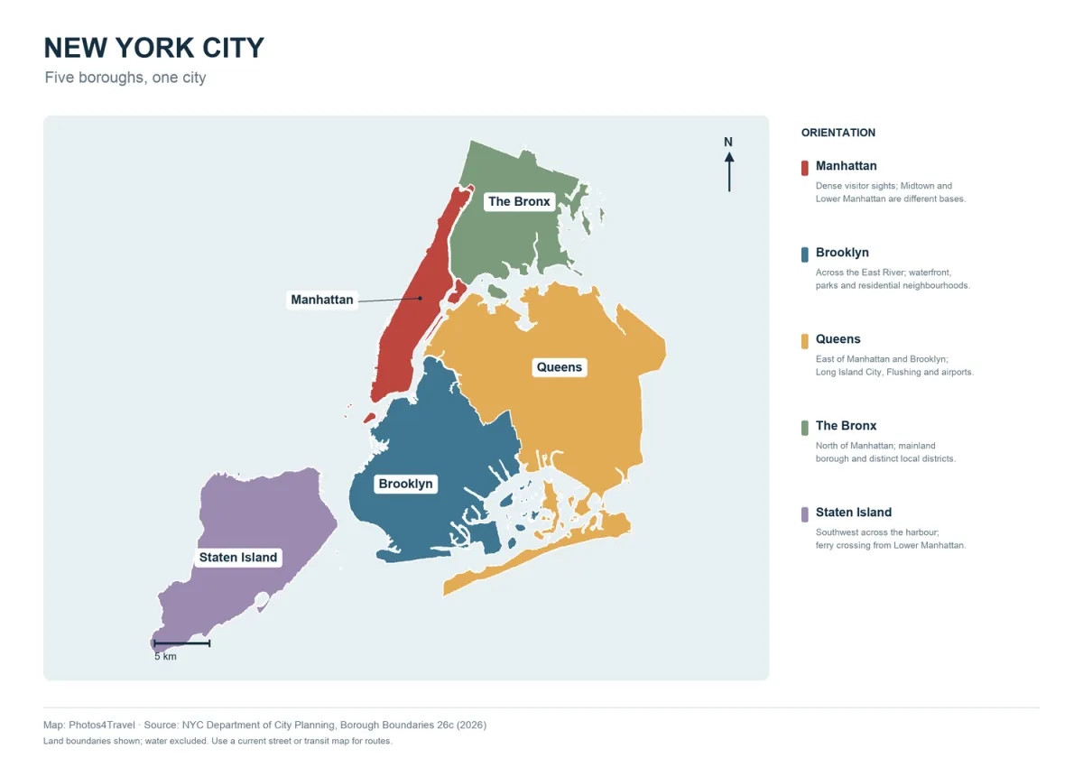
Open full-size New York City map
New York City is a group of connected boroughs, islands and peninsulas, not one continuous Manhattan grid. The map above is an orientation tool for the five boroughs. It is an original Photos4Travel design based on the NYC Department of City Planning’s current 26c borough boundaries, checked on 3 November 2026.
It shows geographic relationships , not a live subway map, an accessible route, traffic conditions or legal neighbourhood boundaries. Open the full-size version to read the labels. Use the current MTA maps for actual transport lines and Where to Stay for accommodation choices.
How the Boroughs Fit Together
On small screens, swipe or scroll this table horizontally. Keyboard users can focus the table area and use the arrow keys.
| Borough | Where it sits | How to use that information |
|---|---|---|
| Manhattan | Long, narrow island between the Hudson and East River waterways | Group nearby visits; north-south distance still matters |
| Brooklyn | West end of Long Island, across the East River from Lower Manhattan | Pair waterfront views with a Brooklyn neighbourhood |
| Queens | East of Manhattan and north/east of Brooklyn on Long Island | Check the actual destination; the borough is much larger than Long Island City |
| The Bronx | North of Manhattan, principally on the mainland | Plan a focused local visit with a real transport connection |
| Staten Island | Southwest across the harbour | The ferry reaches St George, not every island attraction |
Borough boundaries do not tell you the best entrance, station exit or pedestrian crossing. A short straight-line distance across water may involve a bridge, train, bus or ferry and a much longer door-to-door journey.
Manhattan: Use Districts Rather Than One Central Label
Lower Manhattan gathers the harbour, financial district and early city history. Midtown has major rail terminals, theatres, office towers and many first-visit sights. Central Park separates the Upper East and Upper West Sides, and northern Manhattan continues beyond the park into several distinct neighbourhoods.
The numbered grid is useful, but downtown streets do not always follow it. East-west walks can take longer than a quick glance at the map suggests, while a subway express can pass the stop nearest your hotel. Locate your actual entrance and destination before leaving. A useful sightseeing day stays within one broad zone, with a short connection only when it adds something you value.
Brooklyn: Waterfront, Neighbourhoods and Park Distances
DUMBO and Brooklyn Bridge Park sit opposite Lower Manhattan, making them natural partners for a bridge or waterfront visit. Williamsburg is further north on the East River side; Prospect Park and the Brooklyn Museum belong to another useful cluster. Coney Island is much further south and deserves a separate weather-aware journey.
Do not treat all these places as adjacent because they share a borough. Check the connection from the exact hotel or station. If you visit Brooklyn Bridge Park at sunset, leave time to find the viewpoint without blocking a busy path. Parks & Outdoor Activities compares the different outdoor areas instead of repeating them as a landmark checklist.
Queens: Different Districts, Different Reasons to Go
Long Island City is useful for East River waterfront orientation and some transit-linked hotel choices. Astoria and Flushing offer their own food and cultural visits; they are not simply the next street after a Manhattan skyline stop. The airports occupy still different parts of the wider geography: JFK is in southeastern Queens and LaGuardia is towards the north.
Choose a destination within Queens before choosing the line. Some trips are direct from your base while others need a transfer or a bus. For a food outing, identify the actual restaurant or market and combine it with one nearby visit. The experience guide helps decide the purpose of that journey.
The Bronx and Staten Island: Plan Beyond the Arrival Point
The Bronx offers substantial visits such as gardens, museums and the zoo; the station name alone does not establish the correct entrance to a large site. Compare the operator’s directions with the transport route and allow for a final walk. A borough-wide itinerary can be less practical than one main visit and a nearby meal.
The Staten Island Ferry provides a harbour crossing between Lower Manhattan and St George. It does not land on Liberty Island. Arriving at St George also does not mean you have reached every Staten Island park or museum; onward journeys need their own plan. Decide whether the harbour crossing itself is your experience or the start of a longer island outing.
Turn the Map into a Real Route
Mark one morning anchor, one afternoon anchor and your evening plan. Check walking and public-transport links between them, then remove a stop if the route doubles back. Timed admissions and accessibility requirements should shape the order before you add optional sights.
The map shows borough outlines and labels, not individual venue entrances. A ferry terminal, hotel door or museum’s accessible entrance can be on a different side of a large building or park. Check the destination’s own directions. For actual services and elevators, use Getting Around and Accessibility.
Neighbourhood names are useful everyday descriptions and may overlap; this map does not claim to settle their legal limits. Sources, version and changes are recorded below so the geographic basis remains clear.
Travel Tip:
Keep a borough map and a current transport map available offline. They answer different questions: where places sit, and how the service actually connects them.
Sources and Current Checks
Editorial sources checked on 3 November 2026. Check current operating, booking and travel conditions for your dates.
Frequently Asked Questions
Does this map show current subway lines?
No. It is an orientation map using real borough geography. Use current MTA maps and service information for transport.
Is Brooklyn next to every Queens destination?
The boroughs share Long Island but are large. Check the exact places and real journey instead of assuming all destinations in adjacent boroughs are close.
Does the Staten Island Ferry go to the Statue of Liberty?
It crosses the harbour to St George on Staten Island and passes harbour views. It does not land on Liberty Island.
Can I use the map to identify an accessible entrance?
No. Check the actual venue and transport operator for the entrance, route and current elevator status you need.

