

Sign in
For Photos4Travel editors and team members.
Dominican Republic · Map & Regions
Dominican Republic Map & Regions
See where the Dominican Republic is, distinguish Santo Domingo from Punta Cana and use the map to group the north, northeast, southeast and southwest.
On this page · 8 sections ShowHide
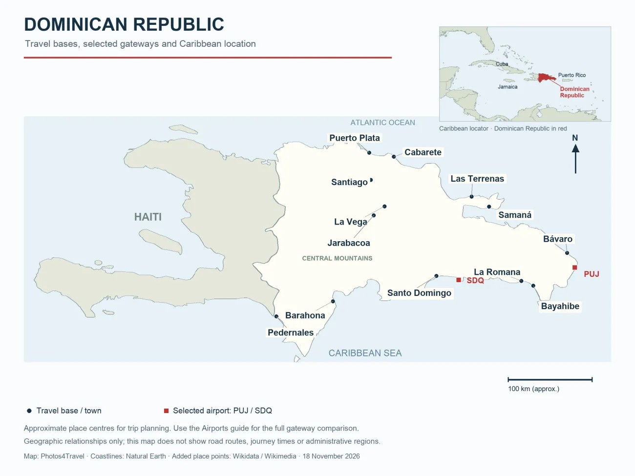
Map: Photos4Travel · Coastlines: Natural Earth (public domain) · Added place points: Wikidata / Wikimedia.
The Dominican Republic is an independent Caribbean country occupying the eastern part of Hispaniola. Haiti occupies the western part of the same island. The Atlantic Ocean lies to the north and the Caribbean Sea to the south. It is a separate country from Dominica and is not part of the United States.
For a first visit, the most useful map question is practical: which places belong together in a route? Santo Domingo and Punta Cana are different destinations, the Samaná Peninsula is not beside every northern resort, and a mountain stay needs more planning than a straight line between two coastal dots suggests. Use the map to choose a manageable part of the country before choosing hotels and transfers.
What this planning map shows
The map combines Natural Earth coastlines with selected place points to show the country’s outline, neighbouring Haiti and 13 travel bases or towns. Bayahibe, Las Terrenas, Cabarete and Jarabacoa are marked alongside the earlier city references. The small Caribbean locator highlights the Dominican Republic in red. Only PUJ and SDQ are shown as airport markers; use the airport guide to compare all six gateways. The descriptive travel regions discussed below are planning areas, not province boundaries.
Thirteen town or base labels are shown: Puerto Plata, Santiago, La Vega, Samaná, Santo Domingo, Bávaro, La Romana, Barahona, Pedernales, Bayahibe, Las Terrenas, Cabarete and Jarabacoa. The airport symbols identify PUJ and SDQ only. They are selected reference points rather than a complete airport inventory. Other useful gateways, including POP, STI, AZS and LRM, are compared in the airport guide.
Use the full-size version to read the labels, then check a current road or navigation service for the particular journey. The scale bar is an approximate geographic reference. It does not convert a straight-line distance into a driving time, show a usable road across a mountain or establish the condition of a hotel’s final access road.
A regional framework for choosing your first base
Swipe or use the arrow keys to compare the complete table.
| Area | Useful reference places | Planning focus | Avoid assuming |
|---|---|---|---|
| Capital and nearby south coast | Santo Domingo; onward coast to the east | City time followed by a separate coastal stay | An airport east of the capital is a city-centre arrival. |
| East and southeast | Bávaro, Punta Cana and La Romana | Match the resort area and gateway, then add selected excursions. | Every hotel marketed as Punta Cana is near the same beach. |
| North coast | Puerto Plata; onward Sosúa and Cabarete | Compare coastal bases and their actual final approaches. | A short line on a national map is a short door-to-door transfer. |
| Northeast | Samaná Peninsula | Choose a particular town and the outings reachable from it. | Samaná town, Las Terrenas and Las Galeras are one resort. |
| Cibao and central highlands | Santiago, La Vega; onward mountain towns | Separate urban, valley and mountain travel days. | Airport-to-town travel includes a rural lodge’s final road. |
| Southwest | Barahona and Pedernales | A deliberate road itinerary with arranged stops and access. | The southwest is a casual add-on to a short eastern resort break. |
Santo Domingo, La Romana and the eastern resorts
Santo Domingo sits on the southern side of the country. It is a city base for the Colonial Zone and other urban visits, rather than another name for a beach-resort region. SDQ lies east of the capital; give a driver your full accommodation address and allow for the final city streets as well as the main road.
La Romana lies farther east along the southeastern side. Bayahíbe is a separate coastal base beyond the city, while Punta Cana and Bávaro occupy the eastern tourism area. The tourism ministry’s gateway guide is useful for matching these destinations to available airports. Compare the actual hotel and flight rather than assigning the same transfer to the whole southeast.
For a short trip, a capital stop and one coastal base can be a workable combination. The geographical relationship is helpful, but it does not mean every resort excursion is close to both. Decide which days belong to the city and which to the coast; repeatedly travelling between distant bases can consume more of a holiday than expected.
The north coast and Santiago
Puerto Plata is the map’s northern coastal reference. Sosúa and Cabarete lie along the wider north-coast corridor, with different beach settings, accommodation and evening arrangements. A route focused here can make more sense than adding the coast as a single outing from an eastern resort.
Santiago is inland, in the Cibao region. It can work as an urban stop or a gateway for onward travel, but it is not a substitute location label for a coastal hotel. When comparing flights into STI and POP, consider the full ground journey in both directions. A good arrival arrangement still needs a reliable plan for reaching the departure airport later.
Mountain and valley travel can fit into a northern or central route when it has its own time. La Vega is a useful map reference for the inland geography, not a statement that every highlands lodge lies beside it. Confirm the final destination and road access before deciding whether a car, driver or bus-and-transfer combination is appropriate.
Samaná is a peninsula, not one interchangeable base
The Samaná label identifies the northeastern peninsula’s principal town reference. Las Terrenas, Santa Bárbara de Samaná and Las Galeras occupy different parts of the area. Choose the specific base according to the outings you want, the arrival gateway and the accommodation’s final access, rather than booking the first property described simply as Samaná.
A beach, waterfall or boat departure can require a road transfer even when it belongs to the same broad peninsula. Ask an operator where the trip actually starts and where you return. The distance between your room and the departure point matters more to the morning schedule than whether both appear in a Samaná search result.
If you combine the peninsula with another region, give the move a realistic part of the itinerary. A compact national map can make a transfer look like a small interruption when it includes checkout, the road journey and finding the next accommodation. Keep weather-sensitive activities away from a tightly fixed departure day.
Barahona and Pedernales: plan a distinct road journey
Barahona and Pedernales show the southwest’s position relative to the capital and the Haitian border. This is a useful direction for travellers who deliberately want a different landscape and a slower road itinerary. It is less suitable as an impulsive extra at the end of a short Punta Cana holiday.
Plan fuel, drinking water, meals and the final approach to accommodation before leaving the larger centres. For a protected area or a boat outing, confirm the permitted entry point, guide or operator and current access. The map does not establish that a road, border crossing or park entrance is open.
Haiti’s presence on the same island is geographical context. Crossing the international border is a separate journey with its own entry requirements and current travel advice. Do not treat a line on this map as an invitation to make an unplanned cross-border excursion.
Turn the geography into a workable route
Mark your arrival airport, departure airport and overnight bases before adding attractions. If most of the route lies on one side of the country, look for a matching gateway or an open-jaw ticket. Then add the activities that fit between those bases rather than stretching the route to collect every place name.
Check the road journey and final approach independently of the map’s straight-line relationships. Make intercity moves in daylight where possible and avoid an ambitious first drive after a long flight. A route with fewer bases can still include varied city, beach and inland experiences while leaving room to change a plan.
Dominican Republic map FAQ
Where is the Dominican Republic?
It is in the Caribbean, on the eastern part of Hispaniola, with the Atlantic Ocean to the north and the Caribbean Sea to the south.
Which country is the Dominican Republic in?
It is itself an independent country. It shares an island with Haiti but has its own government, borders and entry rules.
Is the Dominican Republic part of the United States?
No. It is a separate sovereign country. Do not apply US domestic-travel assumptions to flights, documents or mobile roaming.
Do Haiti and the Dominican Republic share an island?
Yes. Haiti occupies the western part of Hispaniola and the Dominican Republic the eastern part. Their international border and travel requirements remain separate.
Are Santo Domingo and Punta Cana the same place?
No. Santo Domingo is the capital on the southern coast; Punta Cana is an eastern resort area. They require different airport and accommodation decisions.
Tours, Tickets & Experiences
Dominican Republic Travel Tips & Inspiration