

Sign in
For Photos4Travel editors and team members.
Bahamas · Map & Regions
Bahamas Map & Regions: Islands, Bases & Geography
Use a Bahamas island map to understand Nassau, Exuma, Eleuthera, Abaco and more, with practical geography for airports, boat crossings and travel bases.
On this page · 7 sections ShowHide
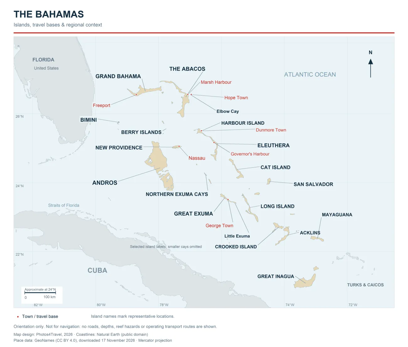
The Bahamas is an Atlantic archipelago, stretching from waters east of Florida towards Cuba and the Turks and Caicos Islands. Its islands may share a destination name, but they do not form one connected road trip. A map is most useful here when it helps you separate places reachable by road, places linked by a local boat, and island groups that require a substantial transfer.
Use the full-size map to orient yourself before choosing hotels or flights. It highlights islands and selected travel bases rather than every cay. It is an orientation map, not a road map or nautical chart: there are no reef depths, navigation channels or operating transport routes. Smaller islands and settlements are not all labelled.
Editorial responsibility: Photos4Travel · Research and editorial standards.
How to read this Bahamas map
Town dots identify selected settlements using gazetteer coordinates. They do not mark airport terminals, ferry docks or hotel entrances. Island names use representative geographic locations; the label may sit beside an island so the coastline remains visible. Thin grey leaders attach labels to places and do not show ferry or flight routes.
The coastlines come from Natural Earth's 1:10 million country data, which is public domain. Place coordinates come from GeoNames under CC BY 4.0. Photos4Travel added the travel labels and design. This degree of coastline detail is appropriate for regional orientation, but cannot show every small cay or establish safe passage between them.
Distances on the page are not journey times. The approximate scale bar is calibrated at 24° north; a straight-line gap across water does not establish a direct service. Compare your intended journey with the transport guide and the operator's actual booking options.
The main geographic groups for travel planning
Swipe sideways on a phone to compare the table. These are practical planning groups rather than administrative boundaries or a complete list of Bahamian islands.
| Group | Places to recognise | Map lesson |
|---|---|---|
| Northwest | Bimini, Grand Bahama, the Abacos | Three separate island systems; proximity to Florida does not join them by road |
| Central west | New Providence, Andros, Berry Islands | Nassau is on a small island, not on the large island of Andros |
| Central east | Eleuthera, Harbour Island, Cat Island | Harbour Island is a separate small island near northern Eleuthera |
| Exuma chain | Northern Exuma Cays, Great and Little Exuma | The northern cays and George Town are different arrival plans |
| South and east | Long Island, San Salvador, Acklins, Crooked Island, Mayaguana, Inagua | Longer onward journeys deserve dedicated nights and confirmed services |
Northwest Bahamas: Bimini, Grand Bahama and Abaco
Bimini lies close to the Florida side of the archipelago. Grand Bahama is farther north, with Freeport marked on its western part. Abaco lies to the east of Grand Bahama. Those relationships help explain why the phrase “near Florida” does not identify one interchangeable destination. Choose the actual island and arrival airport before comparing international fares.
Within Abaco, Marsh Harbour is a main-island base, while Hope Town is on Elbow Cay. Their nearby dots on the regional map still conceal a water crossing. You need the correct departure dock, operating ferry and last return, not merely a driving estimate between two search results. A rental car on Great Abaco does not eliminate the crossing to a cay.
Grand Bahama's long outline also matters after arrival. A Freeport hotel and a park in the eastern part of the island can be separated by a meaningful road journey. Add transport to your activity plan rather than treating everything on the same island as within walking distance. Read the airport guide alongside the map when weighing an arrival late in the day.
Central Bahamas: Nassau, Andros and Eleuthera
New Providence is the relatively small island containing Nassau. Paradise Island is locally connected to Nassau, so a stay there is a different proposition from booking an Out Island flight. This regional map does not resolve street-level approaches or individual bridges; use a current local map for the final journey to your accommodation.
Andros, west and southwest of New Providence, occupies a much larger land area on the map. Its scale and broken waterways are a reminder to ask exactly where an Andros property is located. An arrival airport with “Andros” in the name may still be a poor match for a stay in another part of the island. Geography should inform the airport decision before the accommodation becomes non-refundable.
Eleuthera's long, narrow shape creates another planning trap. North Eleuthera, Governor's Harbour and Rock Sound serve different parts of the island. A fare to the wrong end can add an inconvenient ground transfer. Harbour Island is the small separate island near the northern end: visitors commonly use North Eleuthera Airport, a taxi to Three Island Dock and a water taxi onward. The published Harbour Island arrival instructions illustrate those separate stages.
Cat Island lies farther southeast and should be treated as its own destination. Its position on the same sheet of paper is not evidence of a convenient excursion from Eleuthera. The official islands directory is useful for recognising the distinct island groups before researching detailed access.
Exuma geography: Great Exuma is not the northern cays
The Exumas extend along a chain. George Town and Exuma International Airport serve Great Exuma; Little Exuma is connected to Great Exuma by road bridge. That makes a Great-and-Little-Exuma beach drive a coherent local day. It does not put every famous Exuma attraction beside your hotel.
Staniel Cay and Big Major Cay belong to the northern cays, away from George Town. The original swimming pigs require a boat visit to Big Major Cay. If that outing is your main reason for travelling, compare an appropriate northern-cays base or a clearly described full excursion before choosing a Great Exuma flight. The official Exuma overview distinguishes the main islands and cays.
Stocking Island is a separate island across the harbour from George Town. It is not Lee Stocking Island, and similarly named places should not be treated as alternate spellings. Save the exact destination and agreed landing point offline. The regional map supplies orientation; your boat operator must supply the operational meeting instructions.
Long Island and the southern and eastern islands
Long Island extends southeast of the Exuma area, while San Salvador is farther east. Acklins and Crooked Island, Mayaguana and Inagua form part of the wider archipelago beyond the more familiar resort circuits. Their positions make sense of a slower, focused holiday; they do not justify adding several of them as quick stops between Nassau flights.
For these islands, start with the accommodation's exact location and available arrival route, then work outward. Establish how you will leave as carefully as how you arrive. Travellers with a short stay may gain more from another day in their existing base than from an additional airport day. Detailed boating or independent navigation requires appropriate current charts and local expertise, not this visitor map.
Travel Tip: Write every hotel with its island, nearest suitable airport and final land or water transfer. This small check catches the expensive mistake of booking a familiar island name while picturing a place elsewhere in the chain.
Bahamas map questions
Are the Bahamas in the Caribbean Sea?
The islands are geographically in the Atlantic Ocean, though commonly grouped with Caribbean travel destinations. The map shows their position east of Florida and north of Cuba.
Is Nassau the same island as Paradise Island?
Nassau is on New Providence. Paradise Island is a separate, locally connected island. Reaching it is a local transfer, rather than the domestic-flight journey needed for a distant Out Island.
Is Harbour Island beside Nassau?
No. Harbour Island is near northern Eleuthera. A flight to North Eleuthera still leaves land and water transfers; a Nassau ferry is useful only when a suitable service is actually operating.
Does flying to Great Exuma put me beside the swimming pigs?
No. The original pigs are at Big Major Cay in the northern Exuma Cays. George Town and Great Exuma are another part of the chain, requiring a separately planned excursion.
Can I use this map for driving or boating?
No. It shows regional geography and selected settlements. Use current local road mapping for final approaches and appropriate nautical charts and expertise for navigation.
Tours, Tickets & Experiences
Bahamas Travel Tips & Inspiration


